| |
Geomagnetism |
|
| Home | Magnetic Field Overview | Model and software downloads | Online Calculators | Magnetic Data Sources | Geomagnetic Tutorials |
|---|
The Earth is like a giant magnet, surrounded by a magnetic field. This magnetic field, which is a vector with both direction and intensity, is generated by a dynamo process in the fluid outer core of the Earth. Due to the chaotic movement of the core fluid, the Earth's magnetic field gradually changes over the years. Figure 1 ( and the corresponding animation [50 MB] ) shows the horizontal direction of the magnetic field lines at the surface of the Earth. The magnetic North and South poles are shown as blue and red stars, respectively (note the change in location of the magnetic poles and the change in the speed of movement). Where the lines are blue, the magnetic field dips into the Earth, where they are red it emerges from the Earth. The transition from red to blue, where the field lines are horizontal, is called the magnetic equator. For more information on the magnetic field elements, see the NGDC/WDC answers to Geomagnetic Frequently Asked Questions
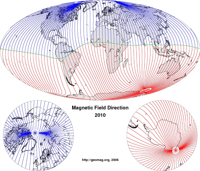
Fig.1: (click to download animation for years 1590-2010 [50 MB])
Horizontal direction of the magnetic field, with the magnetic equator displayed in green.
When using a magnetic compass for navigation, the compass needle points in the direction of the lines displayed in Figure 1. Obviously, this direction is not equivalent with True North. The compass pointing direction can also differ substantially from the direction to the Magnetic North Pole, since magnetic field lines are not just great circles connecting the magnetic poles. Figure 2 ( and the corresponding animation [44 MB] ) illustrates the orientation of compass needles distributed over the surface of the Earth. True North is indicated by the direction of the black lines. The angle between the pointing direction of a compass needle and True North is called magnetic declination, or sometimes, magnetic variation (see below).

(Fig.2: click to download animation for years 1590-2010 [44 MB])
Orientation of magnetic compass needles. True North is indicated by the direction of the black lines (meridians)
Because compasses were used before magnetism was fully understood, the magnetic pole located near Earth's geographic North Pole was called a "Magnetic North Pole", and the tip of a compass needle pointing (roughly) towards the Magnetic North Pole was also called the "Magnetic North Pole" of the needle. Now we know that opposite poles attract. Therefore, one of the poles must be a "Magnetic South Pole". Indeed, the magnetic pole near Earth's geographic North Pole, Earth's Magnetic North Pole is, from a physicists point of view, the southern magnetic pole (magnetic field lines are entering Earth). In Figure 2, this is illustrated by the color RED for a physicist's North pole and BLUE for a physicist's South pole. The red (North) tips of the compass needles are therefore attracted to the blue (south) pole of the Earth. However, convention maintains that the magnetic pole located in the northern hemisphere is called the "north" magnetic pole, while that in the southern hemisphere is the "south" magnetic pole, irregardless of the physics.
The difference between magnetic North and True North is called magnetic declination (or sometimes magnetic variation) and is measured in degrees east (positive) or west (negative) of True North. Shown in Figure 3 ( and the corresponding animation [43 MB] ) are the lines of equal declination (isogonic lines). On the black, agonic line (declination = 0) True North and Magnetic North are identical. In areas of red lines (positive declination) the compass points East of True North, and in areas of blue lines it points West of True North. The magnetic North and South poles are indicated by black stars.
An erratic looking feature at the North geographic pole is due to the fact that the direction of True North changes drastically when stepping from one side of the geographic North Pole to the other side. In the same way, the direction of True North changes drastically when stepping from one side of the geographic South Pole to the other side. This is merely a mathematical complication arising from the definition of declination. As can be seen in Figure 1, a compass could be used for navigation even at the geographic poles, provided the horizontal magnetic field is strong enough to allow for reliable pointing. Presently this is the case at the geographic South Pole, but not at the geographic North Pole.
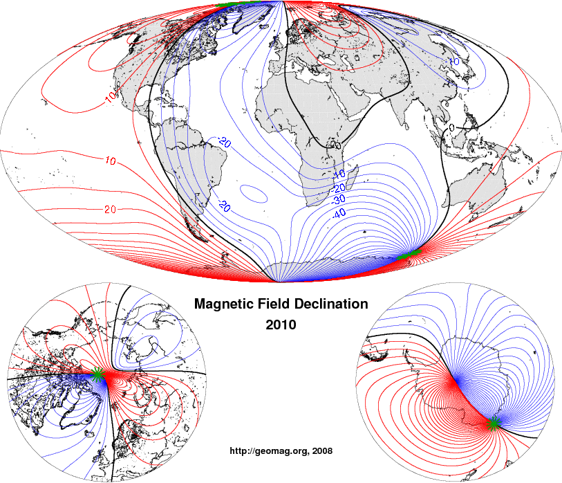
Fig.3: (click to download animation for years 1590-2010 [43 MB])
Lines of equal declination (isogonic lines) of the Earth's magnetic field. Positive lines in red, negative in blue. Along the
black, agonic line (declination = 0), Magnetic North and True North are identical.
In these figures and animations, the magnetic field from 1590 to 1980 is given by the GUFM-1 model of Jackson et al. (2000), while the field from 1980 to 2010 is given by the 10th generation of the International Geomagnetic Reference Field.
Similar animations are also available as Google Earth KMZ and as NOAA's Science on a Sphere .